Integrating Farmer Declarations with Satellite-Derived Crops Classifications: A Geospatial Framework for Supporting Common Agricultural Policy (CAP)
Conference
10th International Conference on Agricultural Statistics
Format: CPS Paper - ICAS 2026
Keywords: "data, europe, geostatistics, policy, remote sensing, web mapping applications
Abstract
Agricultural subsidy payments under the EU's Common Agricultural Policy (CAP) rely on
farmer declarations submitted through the Integrated Administration and Control System
(IACS), recorded in national Geo-Spatial Applications (GSA). Traditional field inspections
verify only a small fraction of parcels due to resource constraints, creating a critical challenge:
how to validate hundreds of thousands of declarations efficiently at scale? Ensuring declaration
accuracy is essential for policy compliance, budget integrity, and reliable agricultural statistics.
Systematic comparison of farmer declarations against independent satellite observations can
identify potential errors, improve data quality, and enable risk-based inspection strategies that
reduce verification costs while maintaining monitoring effectiveness. Understanding when and
why discrepancies occur is crucial for both payment agencies conducting controls and remote
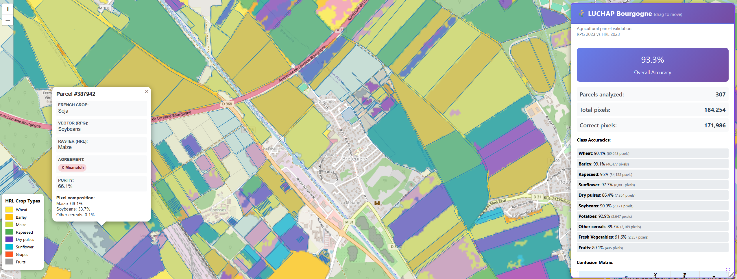
sensing scientists improving classification algorithms. We developed within the Joint Research
Centre (JRC) - Land Unit Characterization for Policies (LUChaP), a web-based validation tool
comparing GSA farmer declarations against the Copernicus High Resolution Layer (HRL), an
automated satellite-derived crop classification at 10-meter resolution. Applied to two case
study regions (Lombardy, Italy and Burgundy, France) covering over 600,000 parcels for the
2021 - 2023 campaign, the platform integrates spatial analysis (parcel size, classification
purity) with temporal validation using Sentinel-2 NDVI profiles extracted from the Copernicus
Data Space Ecosystem (CDSE). The Flask-based architecture employs GeoPandas for efficient
spatial queries and Rasterio for on-demand pixel extraction, enabling interactive exploration of
regional and parcel-level discrepancies. Analysis reveals overall agreement between farmer
declarations and satellite classifications while we noticed systematic mismatch patterns: certain
crop pairs show consistent confusion (e.g., soybeans and maize), small parcels exhibit edge
effects from neighboring fields, and classification purity strongly correlates with mismatch
confidence. NDVI temporal profiles successfully distinguish genuine farmer errors (parcels
following different crop phenology) from satellite technical limitations (small parcels with
mixed pixels or boundary effects). This work demonstrates operational workflows for payment
agencies to prioritize high-risk parcels for inspection, provides feedback to improve satellite
classification algorithms, and offers reproducible validation tools deployable across EU
member states. The platform is operational in the JRC's BDAP environment, enabling auditors and payment agencies to efficiently identify parcels requiring closer verification, supporting
both CAP monitoring and agricultural statistics quality assurance
Figures/Tables
parcel_validation