Crop Area Estimation for Smallholder Farms: Integrating AI with Ground and Satellite Data
Conference
10th International Conference on Agricultural Statistics
Format: CPS Paper - ICAS 2026
Keywords: artificial intelligence, crowdsource, deep learning
Abstract
The global agricultural landscape is predominantly characterized by smallholder farms, which feature complex planting structures and highly fragmented land parcels. This inherent complexity poses a significant challenge for traditional remote sensing methods, as the common issue of mixed pixels in medium-resolution satellite imagery leads to high uncertainty in crop area estimation. However, accurate and timely seasonal crop acreage data is essential for informing agricultural policy, ensuring food security, and understanding the impacts of climate variability and market fluctuations. This study proposes a comprehensive and operational methodology, namely Crop Planting and Type Proportion (CPTP) method, that overcomes these limitations by integrating advanced artificial intelligence (AI) with a synergy of stratified sampling, crowdsourced data, and satellite remote sensing.
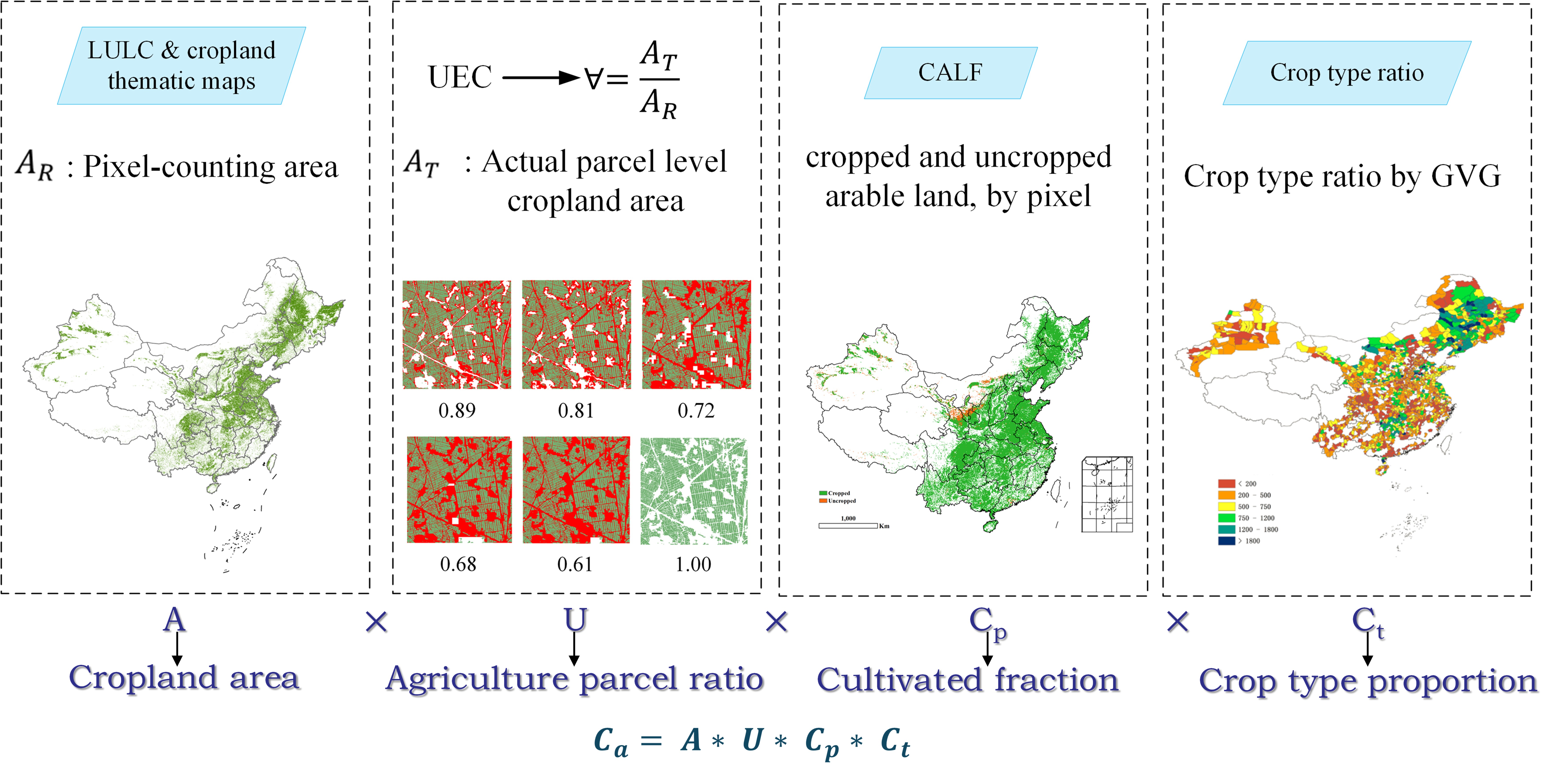
CPTP is a framework that deconstructs the estimation process into four synergistic components. First, a high-resolution (30m) dynamically updated cropland data layer provides the foundational map of arable land, integrating information on cropland types, irrigation, and crop rotation patterns. Secondly, to address the limitations of conventional pixel-counting methods, which are susceptible to scaling effects and classification errors, we have devised a novel Agriculture Parcel Ratio (UEC). This ratio is derived by comparing the actual cultivable area, delineated from very-high-resolution imagery (e.g., Planet), with the pixel-counting area from satellite data layers. A pivotal innovation in artificial intelligence within this framework is the Hierarchical Boundary-guided Network (HBGNet), which was developed for agricultural parcel delineation. This dual-branch multitask architecture is capable of performing parcel semantic feature extraction and boundary feature mining concurrently, resulting in highly accurate field boundary maps derived from satellite imagery. These maps are essential for the calculation of the Universal Earth Curve (UEC).
The UEC effectively eliminates bias from non-cropland objects within the landscape.
The third component involves calculating the Cultivated Arable Land Fraction (CALF) to distinguish between actively cropped and fallow land. The employment of a histogram-based threshold method, applied to dense time-series of Sentinel-2 NDVI data, facilitates the identification of cropping cycles and fallow periods with a high degree of temporal precision. The fourth component is the Crop Type Proportion, which is statistically derived from extensive and rapid field surveys. A dedicated mobile application, designated GVG, was developed to integrate Geographic Information System (GIS), video, and Global Positioning System (GPS) to efficiently collect geotagged crop samples. Furthermore, deep learning models were developed for the automated classification of these in-situ photos, ensuring scalable and high efficiency in crop type identification from the geotagged photos.
The integrated crop area is subsequently calculated as follows: The calculation of crop area is determined by the multiplication of three variables: arable land area, agriculture parcel ratio (UEC), cultivated fraction (CALF), and crop type proportion.
This approach has undergone rigorous testing and validation over the past decade in a variety of regions characterized by diverse agricultural systems. The findings indicate promising results, with reliable estimates of crop area ranging from 97% to 98.8% and crop type proportion accuracy surpassing 98%. The CPTP method has been demonstrated to be effective even in regions prone to cloud cover, thereby overcoming a significant limitation of optical remote sensing. This work proposes a scalable, accurate, and operational solution for estimating crop area in challenging agricultural landscapes.
Figures/Tables
Framework