
Looking Forward: GIS-Based Population Modeling of Australia
Conference
Format: CPS Poster - IAOS 2026
Keywords: forecasting, geospatial, geospatial-analysis, gis, population
Session: Poster Session
Tuesday 12 May 12:30 p.m. - 2:30 p.m. (Europe/Vilnius)
Abstract
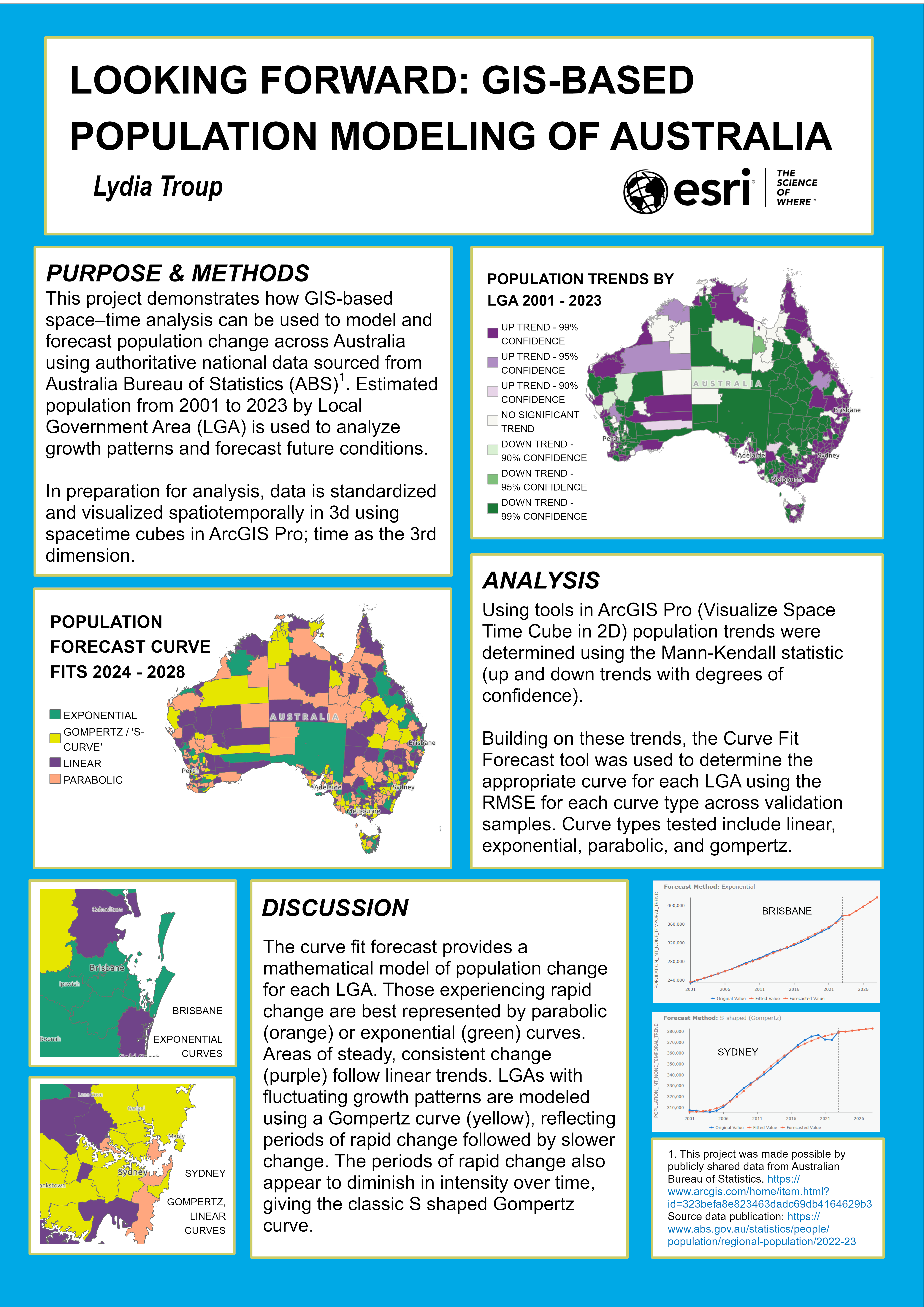
Understanding where and how populations are changing is critical for planning, policy, and resource allocation. This project demonstrates how GIS-based space–time analysis can be used to model and forecast population change across Australia using authoritative national data. Using estimated resident population data from the Australian Bureau of Statistics (ABS), spanning 2001 to 2023 for 566 local government areas (LGAs), we apply Space-Time Pattern Mining tools in ArcGIS Pro to explore historical trends and predict future population values.
The workflow begins with transforming the ABS dataset into a space–time–ready format, including transposing year-based population fields into a time-enabled structure and creating a space time cube, where time is treated as a third dimension alongside geography. This cube enables visual and quantitative exploration of population change across Australia, revealing spatial patterns of growth, decline, and stability.
To forecast future population, multiple space–time forecasting methods are evaluated, with a primary focus on the Curve Fit Forecast tool. This approach fits an optimal curve type—such as linear, exponential, or Gompertz—to each LGA individually, allowing population dynamics to vary between rapidly growing urban regions and slower-changing rural areas. Forecasts are generated five years into the future, producing a new space time cube that supports visualization of projected population centers, trend types, and forecast uncertainty. Residual analysis further highlights where models perform well or diverge from observed data.
Finally, forecasts are shared through interactive web maps and dashboards, demonstrating how GIS-driven population modeling can support exploratory analysis, communication, and decision-making. Together, these methods highlight the power of GIS to move beyond static population maps toward dynamic, predictive insights into Australia’s population future.